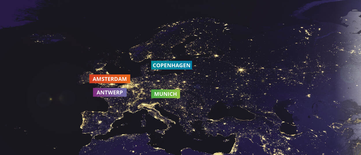
Amsterdam
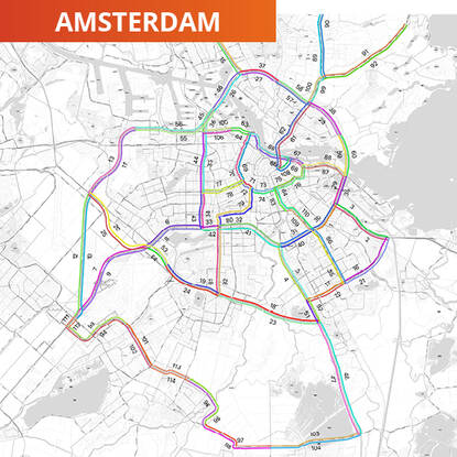
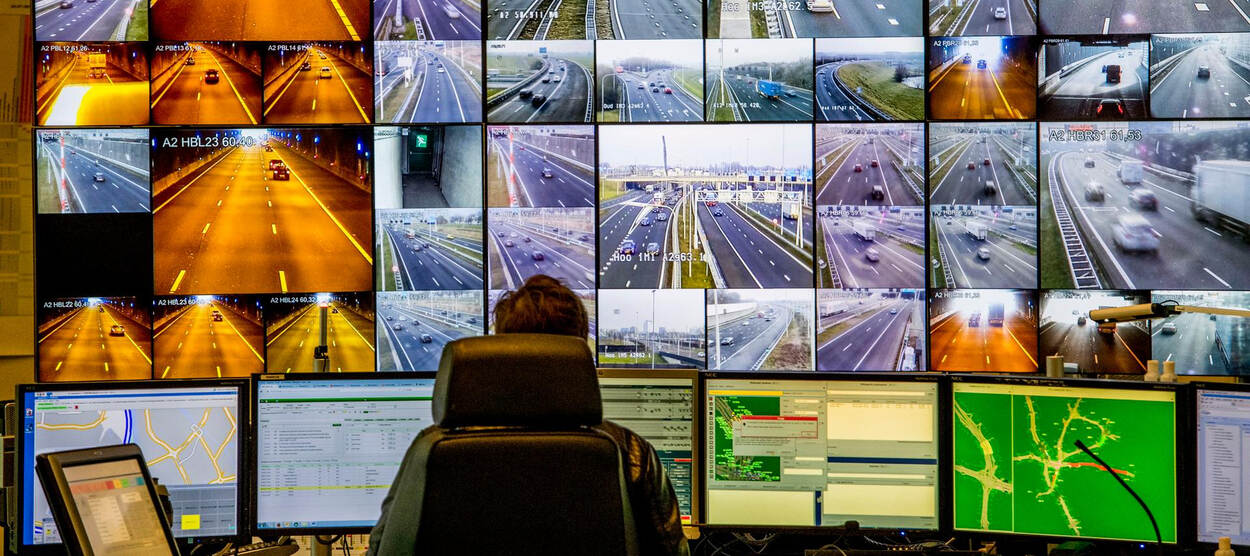
The road network in the Dutch capital Amsterdam is a combination of national roads (A-roads), provincial roads (N-roads) and municipal roads (S-roads). Three road authorities operate here: the City of Amsterdam, the Province of North-Holland and the Directorate-General for Public Works and Water Management (Dutch: Rijkswaterstaat). All three road authorities have their own traffic management centre responsible for monitoring and controlling their road network. Data presenting traffic on these networks is gathered and distributed by the National Road Traffic Data Portal (NDW).
Copenhagen
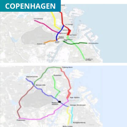
In line with government policy goals to turn Copenhagen into a carbon neutral city by 2025, the pilot in Copenhagen focuses on a multimodal interactive traffic management approach, which includes the integration of multimodal services. The ultimate challenge for the pilot site is to find an approach where interactive traffic management can succeed in using various data and service providers to significantly improve the level of service. The city of Copenhagen has one traffic management centre. It monitors the main city roads for cars and cyclists and is responsible for gathering and distributing data about traffic on the national road network.
Munich
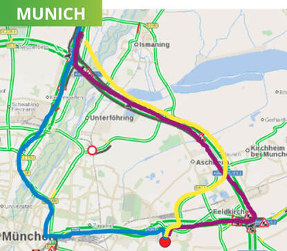
Munich is the capital of the German state of Bavaria. The Munich road network predominantly consists of the national and state roads in and around the metropolitan area of Munich (A-roads or Autobahnen, B-roads and a few lower-order roads, such as St2082). These are monitored and controlled by the traffic management centre of Bavaria. The national access point MDM is responsible for gathering and distributing data about the traffic on the national road network.
Antwerp
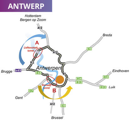
Antwerp, the largest city in Flanders, holds the main port of Belgium. This port is situated along the Scheldt, a large river that divides the city. On the main circular road around Antwerp cars can use two tunnels (A and B) to cross the Scheldt. In normal traffic conditions, there is an unbalanced use of the two tunnels. Where the Kennedytunnel has an average daily traffic volume of 160,000 vehicles, the Liefkenshoektunnel only gets around 40,000 vehicles a day. Since 2002, the Flanders Traffic Management Centre can suspend tolling at the Liefkenshoektunnel when there are incidents that seriously affect the traffic movement. The traffic management centre monitors and controls the national road network around Antwerp. It is also responsible for gathering and distributing data about the traffic on the national road network.
Deployment and operations of interactive traffic management
A total of 22,511 SOCRATES2.0 users have experienced the developed SOCRATES2.0 services
Based on the services described later in this section, we conclude the following:
- From an end-user perspective, the services are focused on clear and direct information about the traffic situation and travel options. There are no hints about the underlying, sometimes complex processes of communication and negotiations between service providers, TMCs and intermediaries. This simplifies the user interaction and acceptance of the traffic management advice.
- In most end-user services, there is a freedom to follow and comply with a traffic management scheme. This is done by for instance actively accepting or denying a rerouting advice. Some services also offer a feedback function, verifying the acceptance and behaviour of a user. With the user being in full charge of their decisions, and allowing communication back to the service provider, this corresponds to our vision of the “customer as the CEO of their journey”
- We experienced that multiple service providers can operate in parallel in the same use case, even with different communication channels (smart phone app, in-car app, social media). This is important as we do not expect there to be a “one size fits all” end-user solution, but we need to utilise all existing and upcoming channels and technologies.
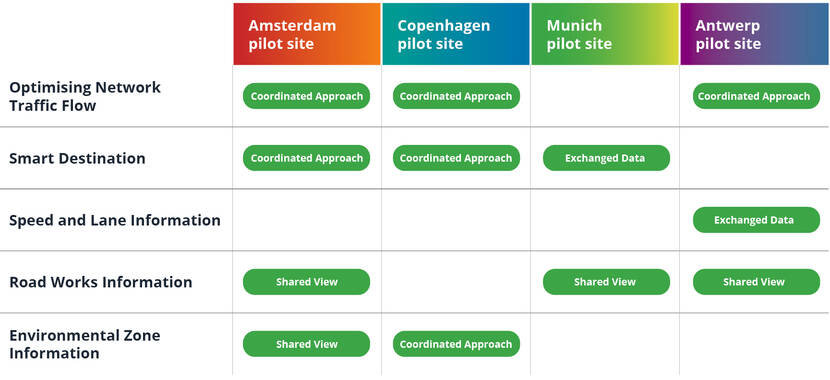
Optimising Network Traffic Flow (Amsterdam, Antwerp and Copenhagen)
Traffic congestion is common during peak hours in these three European cities. Also, the CO2 emissions are high. Roadworks, big events, accidents and heavy weather conditions further reduce network capacity. These use cases focus on improving network performance through a better distribution of traffic
New SOCRATES2.0 services
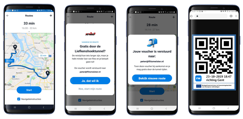
The service providers advise specific groups of travellers to switch routes to avoid traffic congestion. The reroute advice for individual road users often means a longer route, so some services use incentives to test how travellers can be persuaded to take another route. One such incentive is rewards in the form of a toll reduction voucher.
From function to product – Smart Tunnel Service (Antwerp)
Be-Mobile and BMW Smart Tunnel Service
The Smart Tunnel Service provides routing advice to travellers crossing the river Scheldt in Antwerp. If the toll reduction measure is activated, the routing engine in the navigation service will calculate an alternative route via the Liefkenshoektunnel and, depending on expected travel time on this alternative route, the end user will be presented with this option. When the user accepts the alternative route, the voucher is sent and, upon arrival at the Liefkenshoektunnel, they can have their voucher scanned by a toll booth operator and continue their route without paying a toll.
Smart Destination (Amsterdam, Copenhagen and Munich)
When an event is held in one of these three cities, the access roads often become oversaturated. These use cases aim for more satisfied event visitors by improving traffic flow distribution over space and time and offering users optimised dynamic parking guidance. Strategies of preferred routes and available parking facilities are aligned with the event managers and communicated to the users.
New SOCRATES2.0 services
The service providers provide road users with smart individual route guidance. Public traffic management strategies are made available so the service providers can incorporate them into their navigation advice. Potential capacity bottlenecks along the network are identified, as are less desirable roads where pollution is overly high.
From function to product – Smart Destination service (Munich)
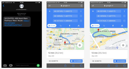
BrandMKRS focuses on the user, which shows that individuals are presented with a genuine overload of information. An innate capacity to filter and order makes this information usable or not, and determines whether drivers follow up on that information or not. Both the source and form of the information have a huge effect on persuasiveness and impact. Advice from a good friend rates as most persuasive, so the best advice to relevant individuals is via trusted communication channels like WhatsApp and Google Maps.
The BrandMKRS service first targets and approaches users on social media, offers them the chance to opt-in to register, and provides them with relevant information.
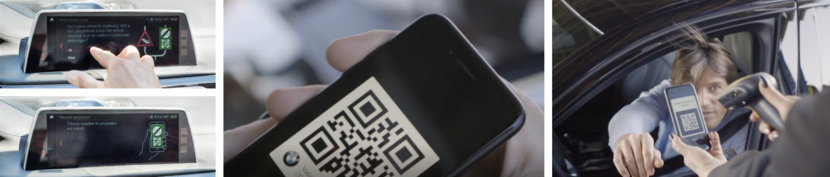
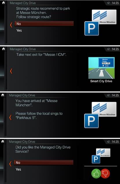
The BMW Group service provides information via an in-car vehicle app. A pop-up appears in the main display when users pass specific geofence areas near the event and on the strategic route segments towards the event area. Users are asked whether they want to follow the strategic route advice towards the event area. If they accept, further in-car pop-ups appear and guide them on the strategic streets towards the preferred parking location as shown below.
Speed and Lane Information (Antwerp)
Road users in the Belgian city are not currently informed in-car about temporary lane openings and closures. This use case aims to correctly show dynamic in-car lane information.
NewSOCRATES2.0 services
The service providers distribute the state of dynamic lanes in-car in real time to enhance traffic safety.
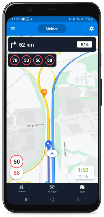
From function to product – Speed & Lane Information service
A large part of the Antwerp motorway network has a lane control system that displays which lanes are open or closed to traffic and also shows speed limits. Be-Mobile’s Speed & Lane Information service provides this information via corresponding images in their Flitsmeister app.
Road Works Information (Amsterdam, Antwerp and Munich)
Currently, service providers and road authorities do not have accurate enough information on roadworks in these three cities. Information is often erroneous, unreliable and insufficient, which leads to unpleasant surprises, congestion and delays. In these use cases, travellers, service providers and the road authority share data to establish a “ground truth” to see how much this improves the quality of the roadworks information.
New SOCRATES2.0 services
The roadworks intermediary service provider delivers common roadworks information based on public and private data. The location, type and timing of roadworks in a specified region are broadcasted to participating parties by means of a news feed.
From function to product – Common Road Works picture
The intermediary service provider combines real-time roadworks information from public sources (planning and real-time data from building and maintenance contractors) and private data service providers (floating car data) into a common roadworks situational picture, including the location, type and timing of the roadworks. This service was tested with multiple public and private data sources in the context of local conditions in Amsterdam, Antwerp and Munich.
Environmental Zone Information (Amsterdam and Copenhagen)
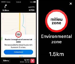
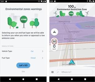
The use cases in these cities aimed to deliver better information about environmental zones to drivers. This helps them make better decisions, avoid running into surprises along the way and avoid getting fined. Green mobility was stimulated by providing information and advice to drivers so they can avoid certain parts of the city and reduce local emission values.
New SOCRATES2.0 services
Several SOCRATES2.0 partners developed environmental zone services based on shared information on access restrictions. When approaching an environmental zone, drivers receive warning messages on access conditions and are rerouted when they are not allowed to enter. Notifications and alternative routes are also sent to road users when certain roads are less ideal because of high pollution levels.
From function to product – Environmental Zone Information
Screenshots of Be-Mobile and TomTom demonstrating the newly launched functionality of the Environmental Zone Information use case in the Truckmeister app and AmiGO app.
Read more on the pilot site operations:
- The SOCRATES2.0 pilot in city of Amsterdam (PDF)
- The SOCRATES2.0 pilot in city of Copenhagen PDF)
- The SOCRATES2.0 pilot in city of Munich (PDF)
- The SOCRATES2.0 pilot in city of Antwerp (PDF)
Watch the video’s in the SOCRATES2.0 Services:
- Copenhagen:
Smart traffic and navigation services for safe mobility and a liveable Copenhagen (YouTube) - Amsterdam:
Proactive route advice in the Amsterdam region (YouTube)
Navigation service with information on environmental zones in the Amsterdam region (YouTube) - Antwerp:
SOCRATES2 0 Smart Tunnel Service (YouTube)